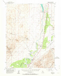
1956 Map of Oreana
USGS Topo · Published 1964About this map
The Humboldt River corridor dominates this mid-century survey, serving as the vital artery for transportation and industry through the Nevada desert. The Southern Pacific railroad follows the river's path, connecting small rail stops and ranching hubs like Rye Patch, Oreana, and Woolsey. The landscape is a study in water management and extraction, from the Rye Patch Reservoir and Rye Patch Dam Spillway in the north to the Upper Valley Canal and Taylor Canal system that irrigates the southern valley floor near Young Ranch.
Find a feature on this map
54 named features on this map. Tap any name to fly to it.
Don’t see what you’re looking for? This feature index may not catch every label — zoom into the map to look around manually.
Map Details
Editions of this 1956 Oreana Map
3 editions found
Other maps of this area

1931 · Lovelock
USGS Topo · 1:250,000

1935 · Lovelock
USGS Topo · 1:250,000

1954 · Unionville
USGS Topo · 1:62,500

1954 · Buffalo Mtn
USGS Topo · 1:62,500

1955 · Lovelock
USGS Topo · 1:250,000

1956 · Oreana
USGS Topo · 1:62,500

1956 · Toulon
USGS Topo · 1:62,500

1956 · Imlay
USGS Topo · 1:62,500

1956 · Lovelock
USGS Topo · 1:62,500

1959 · Lovelock
USGS Topo · 1:250,000