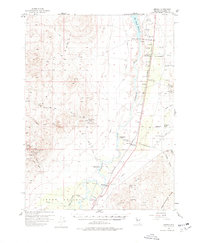
1956 Map of Oreana
USGS Topo · Published 1978About this map
The Humboldt River corridor defines this mid-century portrait of Pershing County, where the industrial legacy of the Trinity Range meets the agricultural developments of the valley. Mining history is deeply etched into the western mountains, with numerous operations like the Jersey Mine, Montezuma Mine, and Morning Star Mine clustered near Arabia. These workings, connected by a network of steep trails and the Poker Brown Road, reflect a period of intensive mineral extraction. Along the valley floor, the Southern Pacific railroad serves as the primary artery, paralleling the river and the Rye Patch Reservoir. Water management is central to the local economy, evidenced by the Rye-Patch Dam and an intricate system of irrigation including the Upper Valley Canal and Emigrant Canal. The presence of the Cerini Ranch (Site) and various active spreads like Cole Ranch and Sheppard Ranch illustrate the transition from early pioneer routes like the Old Emigrant Road to established high-desert ranching.
Find a feature on this map
56 named features on this map. Tap any name to fly to it.
Don’t see what you’re looking for? This feature index may not catch every label — zoom into the map to look around manually.
Map Details
Editions of this 1956 Oreana Map
3 editions found
Other maps of this area

1931 · Lovelock
USGS Topo · 1:250,000

1935 · Lovelock
USGS Topo · 1:250,000

1954 · Unionville
USGS Topo · 1:62,500

1954 · Buffalo Mtn
USGS Topo · 1:62,500

1955 · Lovelock
USGS Topo · 1:250,000

1956 · Oreana
USGS Topo · 1:62,500

1956 · Toulon
USGS Topo · 1:62,500

1956 · Imlay
USGS Topo · 1:62,500

1956 · Lovelock
USGS Topo · 1:62,500

1959 · Lovelock
USGS Topo · 1:250,000