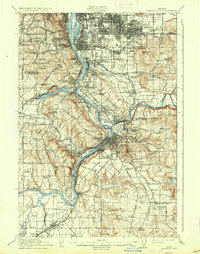
1914 Map of Oregon City
USGS Topo · Published 1937About this map
The Willamette River serves as the central artery for this early 20th-century landscape, where the industrial and residential growth of Oregon City and Portland is deeply intertwined with a complex rail network. Before the widespread dominance of automobiles, the Southern Pacific and Oregon Electric lines, alongside the Cazadero Line, dictated the placement of emerging suburbs like Oak Grove and Jennings Lodge. The map documents a time when the riverfront was a hive of activity, featuring landings such as Ottawa Ldg and Buchmans Ldg, and the early development of Reed College. Rural Clackamas County is dotted with one-room schoolhouses like the Red School and Frogpond School, while the presence of the State Rifle Range and Timm Mill reflects the diverse land use in the hills surrounding Mount Scott and Petes Mountain.
Find a feature on this map
117 named features on this map. Tap any name to fly to it.
Don’t see what you’re looking for? This feature index may not catch every label — zoom into the map to look around manually.
Map Details
Editions of this 1914 Oregon City Map
4 editions found
Other maps of this area

1897 · Portland
USGS Topo · 1:62,500

1905 · Portland
USGS Topo · 1:62,500

1911 · Boring
USGS Topo · 1:48,000

1914 · Boring
USGS Topo · 1:62,500

1914 · Oregon City
USGS Topo · 1:62,500

1915 · Hillsboro
USGS Topo · 1:62,500

1916 · Tualatin
USGS Topo · 1:62,500

1916 · Estacada
USGS Topo · 1:125,000

1918 · Hillsboro
USGS Topo · 1:62,500

1918 · Troutdale
USGS Topo · 1:62,500