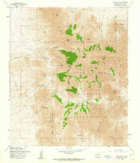
1955 Map of Organ Peak
USGS Topo · Published 1962About this map
The Organ Mountains dominate this mid-century landscape, characterized by dramatic vertical relief and high-altitude peaks such as Rabbit Ears, The Needles, and Organ Needle. This territory serves as a significant intersection of defense and natural topography, with large portions of the terrain encompassed by the Fort Bliss Military Reservation and the White Sands Proving Ground. Local infrastructure at this time was sparse, centered around the airstrip and Hayner Resort tucked below the high peaks.
Find a feature on this map
56 named features on this map. Tap any name to fly to it.
Don’t see what you’re looking for? This feature index may not catch every label — zoom into the map to look around manually.
Map Details
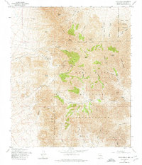
Editions of this 1955 Organ Peak Map
Historical Maps of Boyd Through Time
354 maps found

1916 Tonuco
Doña Ana County, NM

1917 Mt. Riley
Doña Ana County, NM

1917 Noria
Doña Ana County, NM

1918 Mt. Riley
Doña Ana County, NM

1918 Noria
Doña Ana County, NM

1929 Mt. Riley
Doña Ana County, NM

1932 Tonuco
Doña Ana County, NM

1941 Aden
Doña Ana County, NM

1941 Organ Peak
Doña Ana County, NM

1943 Aden
Doña Ana County, NM

1943 Afton
Doña Ana County, NM

1943 Corralitos Ranch
Doña Ana County, NM

1943 Organ Peak
Doña Ana County, NM

1947 Point Of Sands 2
Doña Ana County, NM

1948 Bear Peak
Doña Ana County, NM

1948 Davies Tank
Doña Ana County, NM

1948 Kaylor Mountain
Doña Ana County, NM

1948 Lake Lucero
Doña Ana County, NM

1948 Lake Lucero SW
Doña Ana County, NM

1948 Newman NW
Doña Ana County, NM

1948 San Diego Mountain
Doña Ana County, NM

1950 Lake Lucero
Doña Ana County, NM

1950 Lake Lucero SW
Doña Ana County, NM

1951 Mt. Riley
Doña Ana County, NM

1952 Parker Lake
Doña Ana County, NM

1955 Bishop Cap
Doña Ana County, NM

1955 Davies Tank
Doña Ana County, NM

1955 Newman NW
Doña Ana County, NM

1955 Newman SW
Doña Ana County, NM

1955 Organ Peak
Doña Ana County, NM

1955 Organ Peak NW
Doña Ana County, NM

1955 Strauss
Doña Ana County, NM

1955 Tortugas Mountain
Doña Ana County, NM

1956 Parker Lake
Doña Ana County, NM

1959 Sierra Alta
Doña Ana County, NM

1959 Souse Springs
Doña Ana County, NM

1978 Afton
Doña Ana County, NM

1978 Dona Ana
Doña Ana County, NM

1978 Leasburg
Doña Ana County, NM

1978 Picacho Mountain
Doña Ana County, NM

1981 Bear Peak
Doña Ana County, NM

1981 Bennett Mountain
Doña Ana County, NM

1981 Fleck Draw
Doña Ana County, NM

1981 Gardner Peak
Doña Ana County, NM

1981 Gilmore Draw
Doña Ana County, NM

1981 Goldenburg Draw
Doña Ana County, NM

1981 Hembrillo Canyon
Doña Ana County, NM

1981 San Andres Peak
Doña Ana County, NM

1982 Heart of the Sands NW
Doña Ana County, NM

1982 Heart of the Sands SW
Doña Ana County, NM

1982 Lake Lucero
Doña Ana County, NM

1982 Selden Canyon
Doña Ana County, NM

1982 Selden Canyon NE
Doña Ana County, NM

1982 Summerford Mountain
Doña Ana County, NM

1982 Taylor Well
Doña Ana County, NM

1982 Thorn Well
Doña Ana County, NM

1985 Aden Crater
Doña Ana County, NM

1985 Aden Hills
Doña Ana County, NM

1985 Guzmans Lookout Mountain
Doña Ana County, NM

1985 Kilbourne Hole
Doña Ana County, NM

1985 Lanark
Doña Ana County, NM

1985 Magdalena Gap
Doña Ana County, NM

1985 Magdalena Peak
Doña Ana County, NM

1985 Mount Aden
Doña Ana County, NM

1985 Mount Aden SW
Doña Ana County, NM

1985 Mount Riley
Doña Ana County, NM

1985 Mount Riley SE
Doña Ana County, NM

1985 Noria
Doña Ana County, NM

1985 Potrillo
Doña Ana County, NM

1985 Potrillo Peak
Doña Ana County, NM

1985 Rough And Ready Hills
Doña Ana County, NM

1985 Sleeping Lady Hills
Doña Ana County, NM

1994 Strauss
Doña Ana County, NM

1996 Aden Crater
Doña Ana County, NM

1996 Aden Hills
Doña Ana County, NM

1996 Afton
Doña Ana County, NM

1996 Afton NW
Doña Ana County, NM

1996 Bear Peak
Doña Ana County, NM

1996 Bishop Cap
Doña Ana County, NM

1996 Black Mesa
Doña Ana County, NM

1996 Dona Ana
Doña Ana County, NM

1996 Fleck Draw
Doña Ana County, NM

1996 Gardner Peak
Doña Ana County, NM

1996 Gilmore Draw
Doña Ana County, NM

1996 Goldenburg Draw
Doña Ana County, NM

1996 Kilbourne Hole
Doña Ana County, NM

1996 Lanark
Doña Ana County, NM

1996 Leasburg
Doña Ana County, NM

1996 Little Black Mountain
Doña Ana County, NM

1996 Magdalena Peak
Doña Ana County, NM

1996 Mount Aden
Doña Ana County, NM

1996 Mount Aden SW
Doña Ana County, NM

1996 Mount Riley
Doña Ana County, NM

1996 Noria
Doña Ana County, NM

1996 Organ Peak
Doña Ana County, NM

1996 Organ Peak NW
Doña Ana County, NM

1996 Picacho Mountain
Doña Ana County, NM

1996 San Andres Peak
Doña Ana County, NM

1996 Selden Canyon
Doña Ana County, NM

1996 Selden Canyon NE
Doña Ana County, NM

1996 Sierra Alta
Doña Ana County, NM

1996 Sleeping Lady Hills
Doña Ana County, NM

1996 Souse Springs
Doña Ana County, NM

1996 Strauss
Doña Ana County, NM

1996 Summerford Mountain
Doña Ana County, NM

1996 Taylor Well
Doña Ana County, NM

1996 Thorn Well
Doña Ana County, NM

1996 Tortugas Mountain
Doña Ana County, NM

2001 Rough And Ready Hills
Doña Ana County, NM

2010 Aden Crater
Doña Ana County, NM

2010 Aden Hills
Doña Ana County, NM

2010 Afton
Doña Ana County, NM

2010 Afton NW
Doña Ana County, NM

2010 Bear Peak
Doña Ana County, NM

2010 Bennett Mountain
Doña Ana County, NM

2010 Bishop Cap
Doña Ana County, NM

2010 Black Mesa
Doña Ana County, NM

2010 Davies Tank
Doña Ana County, NM

2010 Dona Ana
Doña Ana County, NM

2010 Fleck Draw
Doña Ana County, NM

2010 Gardner Peak
Doña Ana County, NM

2010 Gilmore Draw
Doña Ana County, NM

2010 Goldenburg Draw
Doña Ana County, NM

2010 Guzmans Lookout Mountain
Doña Ana County, NM

2010 Heart of the Sands NW
Doña Ana County, NM

2010 Heart of the Sands SW
Doña Ana County, NM

2010 Hembrillo Canyon
Doña Ana County, NM

2010 Kilbourne Hole
Doña Ana County, NM

2010 Lake Lucero
Doña Ana County, NM

2010 Lanark
Doña Ana County, NM

2010 Leasburg
Doña Ana County, NM

2010 Little Black Mountain
Doña Ana County, NM

2010 Magdalena Gap
Doña Ana County, NM

2010 Magdalena Peak
Doña Ana County, NM

2010 Mount Aden
Doña Ana County, NM

2010 Mount Aden SW
Doña Ana County, NM

2010 Mount Riley
Doña Ana County, NM

2010 Mount Riley SE
Doña Ana County, NM

2010 Newman NW
Doña Ana County, NM

2010 Newman SW
Doña Ana County, NM

2010 Noria
Doña Ana County, NM

2010 Organ Peak
Doña Ana County, NM

2010 Organ Peak NW
Doña Ana County, NM

2010 Picacho Mountain
Doña Ana County, NM

2010 Potrillo
Doña Ana County, NM

2010 Potrillo Peak
Doña Ana County, NM

2010 Rough and Ready Hills
Doña Ana County, NM

2010 San Andres Peak
Doña Ana County, NM

2010 Selden Canyon
Doña Ana County, NM

2010 Selden Canyon NE
Doña Ana County, NM

2010 Sierra Alta
Doña Ana County, NM

2010 Sleeping Lady Hills
Doña Ana County, NM

2010 Souse Springs
Doña Ana County, NM

2010 Strauss
Doña Ana County, NM

2010 Summerford Mountain
Doña Ana County, NM

2010 Taylor Well
Doña Ana County, NM

2010 Thorn Well
Doña Ana County, NM

2010 Tortugas Mountain
Doña Ana County, NM

2013 Aden Crater
Doña Ana County, NM

2013 Aden Hills
Doña Ana County, NM

2013 Afton
Doña Ana County, NM

2013 Afton NW
Doña Ana County, NM

2013 Bear Peak
Doña Ana County, NM

2013 Bennett Mountain
Doña Ana County, NM

2013 Bishop Cap
Doña Ana County, NM

2013 Black Mesa
Doña Ana County, NM

2013 Davies Tank
Doña Ana County, NM

2013 Dona Ana
Doña Ana County, NM

2013 Fleck Draw
Doña Ana County, NM

2013 Gardner Peak
Doña Ana County, NM

2013 Gilmore Draw
Doña Ana County, NM

2013 Goldenburg Draw
Doña Ana County, NM

2013 Guzmans Lookout Mountain
Doña Ana County, NM

2013 Heart of the Sands NW
Doña Ana County, NM

2013 Heart of the Sands SW
Doña Ana County, NM

2013 Hembrillo Canyon
Doña Ana County, NM

2013 Kilbourne Hole
Doña Ana County, NM

2013 Lake Lucero
Doña Ana County, NM

2013 Lanark
Doña Ana County, NM

2013 Leasburg
Doña Ana County, NM

2013 Little Black Mountain
Doña Ana County, NM

2013 Magdalena Gap
Doña Ana County, NM

2013 Magdalena Peak
Doña Ana County, NM

2013 Mount Aden
Doña Ana County, NM

2013 Mount Aden SW
Doña Ana County, NM

2013 Mount Riley
Doña Ana County, NM

2013 Mount Riley SE
Doña Ana County, NM

2013 Newman NW
Doña Ana County, NM

2013 Newman SW
Doña Ana County, NM

2013 Noria
Doña Ana County, NM

2013 Organ Peak
Doña Ana County, NM

2013 Organ Peak NW
Doña Ana County, NM

2013 Picacho Mountain
Doña Ana County, NM

2013 Potrillo
Doña Ana County, NM

2013 Potrillo Peak
Doña Ana County, NM

2013 Rough and Ready Hills
Doña Ana County, NM

2013 San Andres Peak
Doña Ana County, NM

2013 Selden Canyon
Doña Ana County, NM

2013 Selden Canyon NE
Doña Ana County, NM

2013 Sierra Alta
Doña Ana County, NM

2013 Sleeping Lady Hills
Doña Ana County, NM

2013 Souse Springs
Doña Ana County, NM

2013 Strauss
Doña Ana County, NM

2013 Summerford Mountain
Doña Ana County, NM

2013 Taylor Well
Doña Ana County, NM

2013 Thorn Well
Doña Ana County, NM

2013 Tortugas Mountain
Doña Ana County, NM

2017 Aden Crater
Doña Ana County, NM

2017 Aden Hills
Doña Ana County, NM

2017 Afton
Doña Ana County, NM

2017 Afton NW
Doña Ana County, NM

2017 Bear Peak
Doña Ana County, NM

2017 Bennett Mountain
Doña Ana County, NM

2017 Bishop Cap
Doña Ana County, NM

2017 Black Mesa
Doña Ana County, NM

2017 Davies Tank
Doña Ana County, NM

2017 Dona Ana
Doña Ana County, NM

2017 Fleck Draw
Doña Ana County, NM

2017 Gardner Peak
Doña Ana County, NM

2017 Gilmore Draw
Doña Ana County, NM

2017 Goldenburg Draw
Doña Ana County, NM

2017 Guzmans Lookout Mountain
Doña Ana County, NM

2017 Heart of the Sands NW
Doña Ana County, NM

2017 Heart of the Sands SW
Doña Ana County, NM

2017 Hembrillo Canyon
Doña Ana County, NM

2017 Kilbourne Hole
Doña Ana County, NM

2017 Lake Lucero
Doña Ana County, NM

2017 Lanark
Doña Ana County, NM

2017 Leasburg
Doña Ana County, NM

2017 Little Black Mountain
Doña Ana County, NM

2017 Magdalena Gap
Doña Ana County, NM

2017 Magdalena Peak
Doña Ana County, NM

2017 Mount Aden
Doña Ana County, NM

2017 Mount Aden SW
Doña Ana County, NM

2017 Mount Riley
Doña Ana County, NM

2017 Mount Riley SE
Doña Ana County, NM

2017 Newman NW
Doña Ana County, NM

2017 Newman SW
Doña Ana County, NM

2017 Noria
Doña Ana County, NM

2017 Organ Peak
Doña Ana County, NM

2017 Organ Peak NW
Doña Ana County, NM

2017 Picacho Mountain
Doña Ana County, NM

2017 Potrillo
Doña Ana County, NM

2017 Potrillo Peak
Doña Ana County, NM

2017 Rough and Ready Hills
Doña Ana County, NM

2017 San Andres Peak
Doña Ana County, NM

2017 Selden Canyon
Doña Ana County, NM

2017 Selden Canyon NE
Doña Ana County, NM

2017 Sierra Alta
Doña Ana County, NM

2017 Sleeping Lady Hills
Doña Ana County, NM

2017 Souse Springs
Doña Ana County, NM

2017 Strauss
Doña Ana County, NM

2017 Summerford Mountain
Doña Ana County, NM

2017 Taylor Well
Doña Ana County, NM

2017 Thorn Well
Doña Ana County, NM

2017 Tortugas Mountain
Doña Ana County, NM

2020 Aden Crater
Doña Ana County, NM

2020 Aden Hills
Doña Ana County, NM

2020 Afton
Doña Ana County, NM

2020 Afton NW
Doña Ana County, NM

2020 Bear Peak
Doña Ana County, NM

2020 Bennett Mountain
Doña Ana County, NM

2020 Bishop Cap
Doña Ana County, NM

2020 Black Mesa
Doña Ana County, NM

2020 Davies Tank
Doña Ana County, NM

2020 Dona Ana
Doña Ana County, NM

2020 Fleck Draw
Doña Ana County, NM

2020 Gardner Peak
Doña Ana County, NM

2020 Gilmore Draw
Doña Ana County, NM

2020 Goldenburg Draw
Doña Ana County, NM

2020 Guzmans Lookout Mountain
Doña Ana County, NM

2020 Heart of the Sands NW
Doña Ana County, NM

2020 Heart of the Sands SW
Doña Ana County, NM

2020 Hembrillo Canyon
Doña Ana County, NM

2020 Kilbourne Hole
Doña Ana County, NM

2020 Lake Lucero
Doña Ana County, NM

2020 Lanark
Doña Ana County, NM

2020 Leasburg
Doña Ana County, NM

2020 Little Black Mountain
Doña Ana County, NM

2020 Magdalena Gap
Doña Ana County, NM

2020 Magdalena Peak
Doña Ana County, NM

2020 Mount Aden
Doña Ana County, NM

2020 Mount Aden SW
Doña Ana County, NM

2020 Mount Riley
Doña Ana County, NM

2020 Mount Riley SE
Doña Ana County, NM

2020 Newman NW
Doña Ana County, NM

2020 Newman SW
Doña Ana County, NM

2020 Noria
Doña Ana County, NM

2020 Organ Peak
Doña Ana County, NM

2020 Organ Peak NW
Doña Ana County, NM

2020 Picacho Mountain
Doña Ana County, NM

2020 Potrillo
Doña Ana County, NM

2020 Potrillo Peak
Doña Ana County, NM

2020 Rough and Ready Hills
Doña Ana County, NM

2020 San Andres Peak
Doña Ana County, NM

2020 Selden Canyon
Doña Ana County, NM

2020 Selden Canyon NE
Doña Ana County, NM

2020 Sierra Alta
Doña Ana County, NM

2020 Sleeping Lady Hills
Doña Ana County, NM

2020 Souse Springs
Doña Ana County, NM

2020 Strauss
Doña Ana County, NM

2020 Summerford Mountain
Doña Ana County, NM

2020 Taylor Well
Doña Ana County, NM

2020 Thorn Well
Doña Ana County, NM

2020 Tortugas Mountain
Doña Ana County, NM

2023 Aden Crater
Doña Ana County, NM

2023 Aden Hills
Doña Ana County, NM

2023 Afton
Doña Ana County, NM

2023 Afton NW
Doña Ana County, NM

2023 Bear Peak
Doña Ana County, NM

2023 Bennett Mountain
Doña Ana County, NM

2023 Bishop Cap
Doña Ana County, NM

2023 Black Mesa
Doña Ana County, NM

2023 Davies Tank
Doña Ana County, NM

2023 Dona Ana
Doña Ana County, NM

2023 Fleck Draw
Doña Ana County, NM

2023 Gardner Peak
Doña Ana County, NM

2023 Gilmore Draw
Doña Ana County, NM

2023 Goldenburg Draw
Doña Ana County, NM

2023 Guzmans Lookout Mountain
Doña Ana County, NM

2023 Heart of the Sands NW
Doña Ana County, NM

2023 Heart of the Sands SW
Doña Ana County, NM

2023 Hembrillo Canyon
Doña Ana County, NM

2023 Kilbourne Hole
Doña Ana County, NM

2023 Lake Lucero
Doña Ana County, NM

2023 Lanark
Doña Ana County, NM

2023 Leasburg
Doña Ana County, NM

2023 Little Black Mountain
Doña Ana County, NM

2023 Magdalena Gap
Doña Ana County, NM

2023 Magdalena Peak
Doña Ana County, NM

2023 Mount Aden
Doña Ana County, NM

2023 Mount Aden SW
Doña Ana County, NM

2023 Mount Riley
Doña Ana County, NM

2023 Mount Riley SE
Doña Ana County, NM

2023 Newman NW
Doña Ana County, NM

2023 Newman SW
Doña Ana County, NM

2023 Noria
Doña Ana County, NM

2023 Organ Peak
Doña Ana County, NM

2023 Organ Peak NW
Doña Ana County, NM

2023 Picacho Mountain
Doña Ana County, NM

2023 Potrillo
Doña Ana County, NM

2023 Potrillo Peak
Doña Ana County, NM

2023 Rough and Ready Hills
Doña Ana County, NM

2023 San Andres Peak
Doña Ana County, NM

2023 Selden Canyon
Doña Ana County, NM

2023 Selden Canyon NE
Doña Ana County, NM

2023 Sierra Alta
Doña Ana County, NM

2023 Sleeping Lady Hills
Doña Ana County, NM

2023 Souse Springs
Doña Ana County, NM

2023 Strauss
Doña Ana County, NM

2023 Summerford Mountain
Doña Ana County, NM

2023 Taylor Well
Doña Ana County, NM

2023 Thorn Well
Doña Ana County, NM

2023 Tortugas Mountain
Doña Ana County, NM