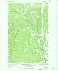
1969 Map of Orient
USGS Topo · Published 1971About this map
The Kettle River carves a deep path through the northern Columbia River Basin, serving as a vital corridor for the Burlington Northern railroad and several small riverbank settlements. In the late 1960s, this landscape is defined by its extraction history, evidenced by the Hidden Treasure Mine and Globe Mine located along the steep slopes of Toulou Mountain. These sites, along with the Cooper Butte Mine, speak to the region's long-standing connection to the mining industry.
Find a feature on this map
40 named features on this map. Tap any name to fly to it.
Don’t see what you’re looking for? This feature index may not catch every label — zoom into the map to look around manually.
Map Details
Editions of this 1969 Orient Map
2 editions found
Other maps of this area

1936 · Marcus
USGS Topo · 1:96,000

1942 · Marcus
USGS Topo · 1:125,000

1948 · Sherman Peak
USGS Topo · 1:62,500

1948 · Kettle Falls
USGS Topo · 1:62,500

1948 · Orient
USGS Topo · 1:62,500

1948 · Togo Mountain
USGS Topo · 1:62,500

1951 · Togo Mountain
USGS Topo · 1:62,500

1951 · Sherman Peak
USGS Topo · 1:62,500

1951 · Orient
USGS Topo · 1:62,500

1951 · Kettle Falls
USGS Topo · 1:62,500