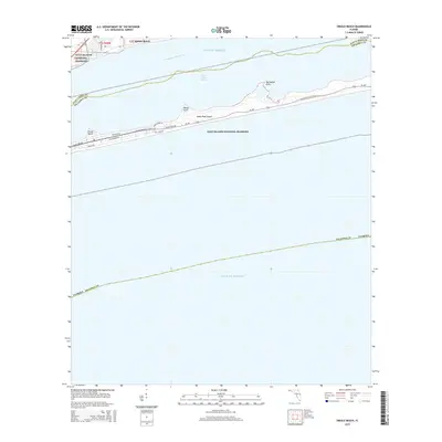
2015 Map of Oriole Beach
USGS Topo · Published 2015About this map
Oriole Beach and the residential area of Villa Hermosa sit along the northern shore of the Santa Rosa Sound in this coastal Florida survey. The map details a landscape dominated by the protected expanses of the Gulf Islands National Seashore, which covers much of the narrow Santa Rosa Island barrier. This island serves as a vital buffer between the sound and the open Gulf of Mexico. Local infrastructure on the island is concentrated along SR-399 and residential streets like Via De Luna Dr and Ariola Dr. These roads provide access to prominent coastal features including Range Point and Big Sabine Point. The Florida National Scenic Trail traverses the length of the seashore, offering a pedestrian path through the dunes and maritime scrub that define the region's shoreline character.
Find a feature on this map
21 named features on this map. Tap any name to fly to it.
Don’t see what you’re looking for? This feature index may not catch every label — zoom into the map to look around manually.
Map Details
Editions of this 2015 Oriole Beach Map
This is the sole edition of this map. No revisions or reprints were ever made.
Other maps of this area

1921 · Holley
USGS Topo · 1:62,500

1921 · Pensacola
USGS Topo · 1:62,500

1936 · Holley
USGS Topo · 1:48,000

1938 · Holley
USGS Topo · 1:62,500

1941 · Pensacola
USGS Topo · 1:62,500

1942 · Pensacola
USGS Topo · 1:62,500
1944 · Oriole Beach
USGS Topo · 1:25,000

1944 · Gulf Breeze
USGS Topo · 1:25,000
1944 · Garcon Point
USGS Topo · 1:25,000
1944 · Pensacola
USGS Topo · 1:25,000