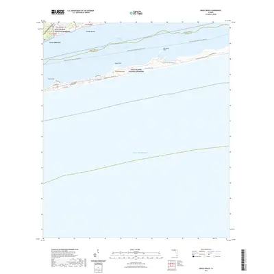
2021 Map of Oriole Beach
USGS Topo · Published 2021About this map
Gulf Islands National Seashore dominates this coastal landscape, protecting the delicate barrier environments of Santa Rosa Island and the adjacent waters. This modern survey illustrates the proximity of residential communities like Oriole Beach and Gulf Breeze to the significant maritime corridor of the Intracoastal Waterway, which cuts through the Santa Rosa Sound. The geography is defined by narrow landforms such as Sharp Point, Range Point, and Big Sabine Point, which serve as critical landmarks for local navigation. The map highlights a modern infrastructure of recreation and preservation, including the Florida National Scenic Trl and the Florida Circumnavigational Paddling Trl, alongside established roadways like J Earle Bowden Way and Gulf Breeze Pkwy, showcasing how this part of Florida balances urban development with vast protected natural zones.
Find a feature on this map
27 named features on this map. Tap any name to fly to it.
Don’t see what you’re looking for? This feature index may not catch every label — zoom into the map to look around manually.
Map Details
Editions of this 2021 Oriole Beach Map
This is the sole edition of this map. No revisions or reprints were ever made.
Other maps of this area

1921 · Holley
USGS Topo · 1:62,500

1921 · Pensacola
USGS Topo · 1:62,500

1936 · Holley
USGS Topo · 1:48,000

1938 · Holley
USGS Topo · 1:62,500

1941 · Pensacola
USGS Topo · 1:62,500

1942 · Pensacola
USGS Topo · 1:62,500
1944 · Oriole Beach
USGS Topo · 1:25,000

1944 · Gulf Breeze
USGS Topo · 1:25,000
1944 · Garcon Point
USGS Topo · 1:25,000
1944 · Pensacola
USGS Topo · 1:25,000