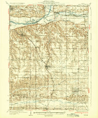
1937 Map of Orion
USGS Topo · Published 1937About this map
Orion serves as a central hub in this depiction of the Illinois prairie during the early 1930s, where the intersection of the Chicago Rock Island and Pacific and the Rock Island and Pacific railroads dictates the local economy. The landscape is defined by the heavy presence of rural education and social infrastructure, seen in the dense distribution of country schoolhouses such as Kingdom Sch, Happy Corner Sch, and Mt Pleasant Sch. The northern boundary is shaped by the Rock River and the Green River Canal, while the southern reaches follow the winding course of the Edwards River. Notable landmarks include the County Farm and the Lutheran Home, providing a record of the community-based care and institutional life in Henry Co and Rock Island Co before the mid-century consolidation of many such rural sites.
Find a feature on this map
84 named features on this map. Tap any name to fly to it.
Don’t see what you’re looking for? This feature index may not catch every label — zoom into the map to look around manually.
Map Details
Editions of this 1937 Orion Map
2 editions found

Other maps of this area

1891 · Davenport
USGS Topo · 1:62,500

1892 · Leclaire
USGS Topo · 1:62,500

1893 · Leclaire
USGS Topo · 1:62,500

1894 · Davenport
USGS Topo · 1:62,500

1899 · Clinton
USGS Topo · 1:125,000

1901 · Rock Island
USGS Topo · 1:125,000

1910 · Rock Island
USGS Topo · 1:125,000

1912 · Milan
USGS Topo · 1:62,500

1923 · Alexis
USGS Topo · 1:62,500

1925 · Alexis
USGS Topo · 1:62,500