
1937 Map of Orion
USGS Topo · Published 1937About this map
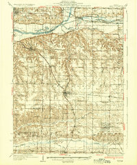
The Illinois and Mississippi Canal cuts across the northern landscape of this 1937 survey, following the Green River through a region defined by intense agricultural development and early 20th-century transportation. The map reveals a dense network of rural infrastructure, notably the numerous country schoolhouses such as Osco Center Sch, Happy Corner Sch, and Town Hall Sch that served dispersed farming families. These schools, often named for local landmarks or sentiments, provide a fine-grained view of the township system in Western and Osco.
Find a feature on this map
81 named features on this map. Tap any name to fly to it.
Don’t see what you’re looking for? This feature index may not catch every label — zoom into the map to look around manually.
Map Details
Editions of this 1937 Orion Map
2 editions found
Other maps of this area

1891 · Davenport
USGS Topo · 1:62,500

1892 · Leclaire
USGS Topo · 1:62,500

1893 · Leclaire
USGS Topo · 1:62,500

1894 · Davenport
USGS Topo · 1:62,500

1899 · Clinton
USGS Topo · 1:125,000

1901 · Rock Island
USGS Topo · 1:125,000

1910 · Rock Island
USGS Topo · 1:125,000

1912 · Milan
USGS Topo · 1:62,500

1923 · Alexis
USGS Topo · 1:62,500

1925 · Alexis
USGS Topo · 1:62,500