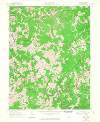
1965 Map of Orlando
USGS Topo · Published 1967About this map
The Little Kanawha River carves a winding path through this central West Virginia landscape, serving as a primary geographic anchor for the rural communities of Salt Lick and Collins Settlement. During the mid-1960s, this region was defined by a scattered network of small hubs like Bulltown, Napier, and Orlando, the latter situated at a junction of the Baltimore and Ohio railroad. The map documents an economy and social structure tied to the land, evidenced by numerous Gas Wells and Oil Wells dotting the hillsides, alongside vital local institutions such as St Michaels Ch, Olive Chapel, and the Riffle Sch. The terrain is characterized by sharp ridges and deep runs, including Clover Fork and Knawl Creek, where family history is etched into the topography through sites like Casta Cem and Ratcliff Sch.
Find a feature on this map
65 named features on this map. Tap any name to fly to it.
Don’t see what you’re looking for? This feature index may not catch every label — zoom into the map to look around manually.
Map Details
Editions of this 1965 Orlando Map
3 editions found
Other maps of this area

1893 · Buckhannon
USGS Topo · 1:125,000

1893 · Sutton
USGS Topo · 1:125,000

1896 · Buckhannon
USGS Topo · 1:125,000

1897 · Buckhannon
USGS Topo · 1:125,000

1906 · Burnsville
USGS Topo · 1:62,500

1908 · Sutton
USGS Topo · 1:48,000

1910 · Sutton Special
USGS Topo · 1:62,500

1912 · Crawford
USGS Topo · 1:48,000

1913 · Hacker Valley
USGS Topo · 1:48,000

1914 · Crawford
USGS Topo · 1:62,500