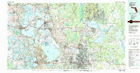
1979 Map of Orlando
USGS Topo · Published 1980About this map
The massive basin of Lake Apopka and the northern reaches of Ocala National Forest anchor this late 1970s overview of Central Florida. The landscape is defined by its hydraulic complexity, featuring the expansive chain of lakes including Lake Harris, Lake Eustis, and Lake Dora near the established citrus and rail centers of Leesburg, Tavares, and Mount Dora. To the east, the St Johns River winds through Lake Monroe and Lake Jessup, framing the growth of Sanford and the Sanford Naval Air Station.
Find a feature on this map
129 named features on this map. Tap any name to fly to it.
Don’t see what you’re looking for? This feature index may not catch every label — zoom into the map to look around manually.
Map Details
Editions of this 1979 Orlando Map
3 editions found
Other maps of this area

1893 · Panasoffkee
USGS Topo · 1:62,500

1895 · Panasoffkee
USGS Topo · 1:62,500

1895 · Ocala
USGS Topo · 1:62,500

1937 · Port Orange
USGS Topo · 1:48,000

1943 · Port Orange
USGS Topo · 1:62,500

1944 · Port Orange
USGS Topo · 1:62,500

1949 · Osceola
USGS Topo · 1:24,000

1950 · Maytown
USGS Topo · 1:24,000

1950 · Edgewater
USGS Topo · 1:24,000

1950 · Aurantia
USGS Topo · 1:24,000