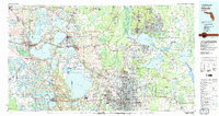
1979 Map of Orlando
USGS Topo · Published 1992About this map
Orlando and its neighboring citrus and lake country appear in this late 1970s survey, capturing the region during a period of significant suburban expansion. The sprawling waters of Lake Apopka and the interconnected chain of lakes including Lake Harris, Lake Eustis, and Lake Dora dominate the western landscape, while the St. Johns River system defines the eastern corridor through Lake Monroe and Lake Jesup. The map traces the established infrastructure of the Seaboard Coast Line railroad and the emerging highway network of Florida'S Turnpike and I-4 that fueled growth in communities like Winter Park, Maitland, and Altamonte Springs. To the north, the protected wilderness of the Ocala National Forest provides a sharp contrast to the developing residential grids. This record preserves the footprint of central Florida before the massive intensification of the late 20th century, showing the original character of towns like Sanford and Mount Dora.
Find a feature on this map
191 named features on this map. Tap any name to fly to it.
Don’t see what you’re looking for? This feature index may not catch every label — zoom into the map to look around manually.
Map Details
Editions of this 1979 Orlando Map
3 editions found
Other maps of this area

1893 · Panasoffkee
USGS Topo · 1:62,500

1895 · Panasoffkee
USGS Topo · 1:62,500

1895 · Ocala
USGS Topo · 1:62,500

1937 · Port Orange
USGS Topo · 1:48,000

1943 · Port Orange
USGS Topo · 1:62,500

1944 · Port Orange
USGS Topo · 1:62,500

1949 · Osceola
USGS Topo · 1:24,000

1950 · Maytown
USGS Topo · 1:24,000

1950 · Edgewater
USGS Topo · 1:24,000

1950 · Aurantia
USGS Topo · 1:24,000