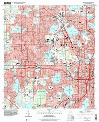
1995 Map of Orlando West
USGS Topo · Published 2000About this map
Eatonville and Lockhart anchor the northern reaches of this mid-1990s landscape, illustrating the dense suburban and industrial evolution of western Orange County. The area is defined by a intricate mosaic of water bodies, including Lake Fairview, Lawne Lake, and Lake Wekiva, which separate residential developments from major infrastructure. Significant landmarks such as the Tangerine Bowl and City Hall mark the transition toward the urban core of Orlando.
Find a feature on this map
99 named features on this map. Tap any name to fly to it.
Don’t see what you’re looking for? This feature index may not catch every label — zoom into the map to look around manually.
Map Details
Editions of this 1995 Orlando West Map
This is the sole edition of this map. No revisions or reprints were ever made.
Other maps of this area

1953 · Lake Jessamine
USGS Topo · 1:24,000

1953 · Pine Castle
USGS Topo · 1:24,000

1953 · Windermere
USGS Topo · 1:24,000

1955 · Orlando
USGS Topo · 1:250,000

1956 · Winter Garden
USGS Topo · 1:24,000

1956 · Orlando West
USGS Topo · 1:24,000

1956 · Orlando East
USGS Topo · 1:24,000

1957 · Orlando
USGS Topo · 1:250,000

1958 · Orlando
USGS Topo · 1:250,000

1959 · Forest City
USGS Topo · 1:24,000