1944 Map of Ormond
USGS Topo · Published 1957About this map
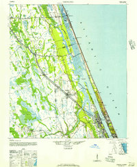
The coastal strip and inland wetlands of Volusia and Flagler Counties are captured here during the mid-1940s, a period when the Florida East Coast railway served as the primary corridor for movement and commerce. This transit spine connects inland settlements like Dupont, Korona, and Favorita to the growing community of Ormond further south. Near the coast, the Halifax River and the Intracoastal Waterway parallel the shoreline, separated from the Atlantic Ocean by a thin barrier of land supporting Flagler Beach.
Find a feature on this map
34 named features on this map. Tap any name to fly to it.
Don’t see what you’re looking for? This feature index may not catch every label — zoom into the map to look around manually.
Map Details
Editions of this 1944 Ormond Map
2 editions found
Other maps of this area

1927 · Matanzas
USGS Topo · 1:48,000

1937 · Dinner Island
USGS Topo · 1:48,000

1937 · Port Orange
USGS Topo · 1:48,000

1937 · Ormond
USGS Topo · 1:48,000

1943 · Dinner Island
USGS Topo · 1:62,500

1943 · Matanzas
USGS Topo · 1:62,500

1943 · Port Orange
USGS Topo · 1:62,500

1944 · Ormond
USGS Topo · 1:62,500

1944 · Dinner Island
USGS Topo · 1:62,500

1944 · Matanzas
USGS Topo · 1:62,500