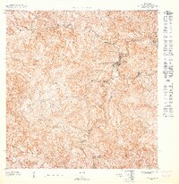
1947 Map of Orocovis NE
USGS Topo · Published 1947About this map
The town of Orocovis sits at the heart of this 1940s topographic study, situated where the Río Orocovis winds through the interior highlands of Puerto Rico. This preliminary survey, prepared under the direction of Orlando R. Méndez for the Departamento del Interior, captures a landscape defined by sharp elevation changes and high-altitude landmarks like Cerro Pío and VABM Bauta. The concentration of structures in the town center contrasts with the scattered rural settlements across the ridges, where local education is anchored by the Escuela Salto and the Escuela Segunda Unidad de Bauta. Waterways like the Río Culebra and Río Bauta dominate the drainage patterns of this territory, providing a detailed record of the island's interior before significant modern development altered the rural road networks and agricultural footprint.
Find a feature on this map
9 named features on this map. Tap any name to fly to it.
Don’t see what you’re looking for? This feature index may not catch every label — zoom into the map to look around manually.
Map Details
Editions of this 1947 Orocovis NE Map
This is the sole edition of this map. No revisions or reprints were ever made.
Historical Maps of Pellejas Through Time
Featured Locations
- Orocovis, Orocovis
- Sana Muerto, Orocovis
- Sector Colí, Orocovis
- Sector Díaz, Orocovis
- Sector El Pueblito, Orocovis