
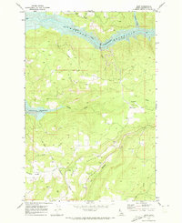
1967 Map of Orofino West
USGS Topo · Published 1971About this map
Orofino serves as the primary hub along the northern bank of the Clearwater River, where the town's development in the late 1960s is marked by institutional landmarks like State Hospital North and the Orofino High School. The landscape transitions sharply from the river valley to the high tablelands of Central Ridge, a transition defined by steep drainages including Little Canyon Creek and Nichols Canyon. This survey captures the rural infrastructure of the era, from the Municipal Airport near Riverside to the dispersed settlements at Gilbert and the former Russell. Genealogists will find notable value in the location of the Riverside Cemetery and Central Ridge Cemetery, which anchor the small upland communities. The map also illustrates the engineering required to traverse this vertical terrain, most notably the winding road labeled Grade descending from the plateau toward the river.
Find a feature on this map
24 named features on this map. Tap any name to fly to it.
Don’t see what you’re looking for? This feature index may not catch every label — zoom into the map to look around manually.
Map Details
Editions of this 1967 Orofino West Map
This is the sole edition of this map. No revisions or reprints were ever made.
Other maps of this area

1924 · Kamiah
USGS Topo · 1:125,000

1955 · Pullman
USGS Topo · 1:250,000

1958 · Pullman
USGS Topo · 1:250,000

1961 · Ahsahka
USGS Topo · 1:62,500

1967 · Mohler
USGS Topo · 1:24,000

1967 · Fletcher
USGS Topo · 1:24,000

1967 · Sixmile Creek
USGS Topo · 1:24,000

1967 · Peck
USGS Topo · 1:24,000

1967 · Orofino East
USGS Topo · 1:24,000
1969 · Dent
USGS Topo · 1:24,000