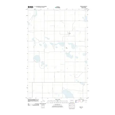
2011 Map of Orrin
USGS Topo · Published 2011About this map
Orrin anchors this Pierce County landscape, appearing as a small rural settlement in the early 21st century. The surrounding terrain is defined by a complex network of seasonal wetlands and prairie potholes, characteristic of the Drift Prairie region. These numerous unnamed water bodies intersperse with a rigid section-line road grid, including routes like 47th St NE and 20th Ave NE. To the south of the town center lies the Saint Mathis Cemetery, a significant point of interest for genealogists and those researching local family history in this corner of North Dakota. The map's sparse development reflects the enduring agricultural character of the area, where human presence is marked primarily by isolated farmsteads and these strictly maintained township roads.
Find a feature on this map
18 named features on this map. Tap any name to fly to it.
Don’t see what you’re looking for? This feature index may not catch every label — zoom into the map to look around manually.
Map Details
Editions of this 2011 Orrin Map
This is the sole edition of this map. No revisions or reprints were ever made.
Other maps of this area

1930 · Drake
USGS Topo · 1:62,500

1940 · Aylmer
USGS Topo · 1:62,500

1954 · Minot
USGS Topo · 1:250,000

1954 · McClusky
USGS Topo · 1:250,000

1955 · Rangeley NE
USGS Topo · 1:24,000

1957 · Rangeley SE
USGS Topo · 1:24,000

1958 · McClusky
USGS Topo · 1:250,000

1958 · Minot
USGS Topo · 1:250,000
1958 · Anamoose
USGS Topo · 1:24,000

1958 · Balta SE
USGS Topo · 1:24,000