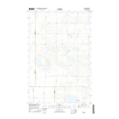
2014 Map of Orrin
USGS Topo · Published 2014About this map
The small settlement of Orrin sits at the intersection of Main St and CR-3532, serving as a central point in this prairie landscape of the early 21st century. The map illustrates a region defined by its numerous small lakes and depressions, a characteristic glacial terrain that transitions across the boundary of McHenry Co and Pierce Co. To the south of the town, Saint Mathis Cem provides a specific point of interest for genealogists researching local families. Further south, the terrain levels out into the broad expanse of Antelope Valley, where the local road network, including ND-19, follows the strict section lines of the Public Land Survey System. This grid of avenues and streets, such as 20th Ave NE and 47th St NE, highlights the agricultural organization of the North Dakota countryside.
Find a feature on this map
24 named features on this map. Tap any name to fly to it.
Don’t see what you’re looking for? This feature index may not catch every label — zoom into the map to look around manually.
Map Details
Editions of this 2014 Orrin Map
This is the sole edition of this map. No revisions or reprints were ever made.
Other maps of this area
1930 · Drake
USGS Topo · 1:62,500
1940 · Aylmer
USGS Topo · 1:62,500
1954 · Minot
USGS Topo · 1:250,000
1954 · McClusky
USGS Topo · 1:250,000
1955 · Rangeley NE
USGS Topo · 1:24,000
1957 · Rangeley SE
USGS Topo · 1:24,000
1958 · McClusky
USGS Topo · 1:250,000
1958 · Minot
USGS Topo · 1:250,000
1958 · Anamoose
USGS Topo · 1:24,000
1958 · Balta SE
USGS Topo · 1:24,000