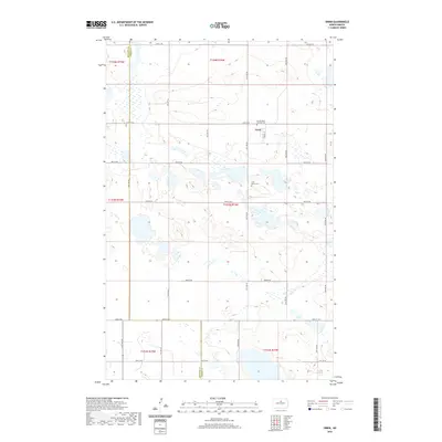
2020 Map of Orrin
USGS Topo · Published 2020About this map
Orrin serves as the central hub of this prairie landscape, situated near the intersection of Main St and 47th St NE. The settlement's religious and community history is anchored by Sacred Heart Catholic Cem, located just north of the town site, and Saint Mathis Cem to the south. This area of Pierce County is defined by a dense concentration of small glacial wetlands and depressions that punctuate the terrain, influencing the grid of local roads including 41st St NE and 49th St NE. The mapping reflects the enduring rectangular survey system of the North Dakota plains, showing the clear boundaries of townships like t154n r74w and t153n r74w within this predominantly agricultural region.
Find a feature on this map
18 named features on this map. Tap any name to fly to it.
Don’t see what you’re looking for? This feature index may not catch every label — zoom into the map to look around manually.
Map Details
Editions of this 2020 Orrin Map
This is the sole edition of this map. No revisions or reprints were ever made.
Other maps of this area

1930 · Drake
USGS Topo · 1:62,500

1940 · Aylmer
USGS Topo · 1:62,500

1954 · Minot
USGS Topo · 1:250,000

1954 · McClusky
USGS Topo · 1:250,000

1955 · Rangeley NE
USGS Topo · 1:24,000

1957 · Rangeley SE
USGS Topo · 1:24,000

1958 · McClusky
USGS Topo · 1:250,000

1958 · Minot
USGS Topo · 1:250,000
1958 · Anamoose
USGS Topo · 1:24,000

1958 · Balta SE
USGS Topo · 1:24,000