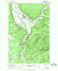
1956 Map of Orting
USGS Topo · Published 1969About this map
The confluence of the Puyallup River and Carbon River anchors this mid-century look at Pierce County, where the settlement of Orting sits protected by a system of levees. The landscape reflects a mix of institutional presence and resource-based industry, featuring the State Soldiers Home south of the main townsite and the Puyallup River Fish Hatchery nestled near the riverbanks. Commercial transport is defined by the Northern Pacific and the Chicago Milwaukee St Paul and Pacific railroads, which parallel the watercourses and service small outposts like Crocker and Tanwax. To the east, the terrain rises sharply toward Spar Pole Hill, where numerous creeks such as Voight Creek and Beane Creek carve through the timbered uplands. This 1950s survey, updated with late-1960s cultural revisions, documents a valley floor transitioning between agricultural use and expanding infrastructure like the Microwave Relay Sta and local gravel operations.
Find a feature on this map
38 named features on this map. Tap any name to fly to it.
Don’t see what you’re looking for? This feature index may not catch every label — zoom into the map to look around manually.
Map Details
Editions of this 1956 Orting Map
5 editions found

Other maps of this area

1897 · Tacoma
USGS Topo · 1:125,000

1900 · Tacoma
USGS Topo · 1:125,000

1937 · Eatonville
USGS Topo · 1:125,000

1941 · Tanwax Lake
USGS Topo · 1:62,500

1941 · Tacoma South
USGS Topo · 1:62,500

1942 · Lake Tapps
USGS Topo · 1:62,500

1944 · Lake Tapps
USGS Topo · 1:62,500

1944 · Tacoma South
USGS Topo · 1:62,500

1944 · Ohop Valley
USGS Topo · 1:62,500

1949 · Ohop Valley
USGS Topo · 1:62,500