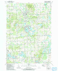
1991 Map of Ortonville
USGS Topo · Published 1991About this map
The village of Ortonville serves as the hub of this northern Oakland County landscape, characterized by its numerous glacial lakes and expansive public lands. To the north, the Ortonville State Recreation Area dominates the terrain, while the Holly State Recreation Area and Independence Oaks County Park provide significant green space to the west and south. This 1991 update reveals a region transitioning from rural agricultural roots to a residential and recreational corridor, evidenced by developments like Brandon Gardens and Jossman Acres. An Old Railroad Grade traces a path through the northwest, a reminder of former transportation networks. The map is particularly useful for genealogical research, identifying numerous local landmarks including Carmer, Eaton, and Ortonville cemeteries, alongside rural institutions like Mt Bethel Ch and the Bald Eagle Burial Ground.
Find a feature on this map
101 named features on this map. Tap any name to fly to it.
Don’t see what you’re looking for? This feature index may not catch every label — zoom into the map to look around manually.
Map Details
Editions of this 1991 Ortonville Map
This is the sole edition of this map. No revisions or reprints were ever made.
Other maps of this area

1907 · Pontiac
USGS Topo · 1:62,500

1909 · Milford
USGS Topo · 1:62,500

1920 · Holly
USGS Topo · 1:62,500

1922 · Holly
USGS Topo · 1:62,500

1936 · Highland
USGS Topo · 1:31,680

1936 · Clarkston
USGS Topo · 1:31,680

1936 · Pontiac North
USGS Topo · 1:31,680

1942 · Highland
USGS Topo · 1:24,000

1943 · Holly
USGS Topo · 1:62,500

1943 · Clarkston
USGS Topo · 1:24,000
Featured Places
- Independence Charter Township, MI
- Springfield Charter Township, MI
- Ortonville, MI
- Brandon Charter Township, MI
- Groveland Township, MI