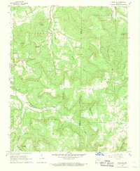
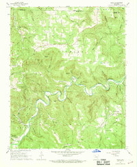
1968 Map of Osage NE
USGS Topo · Published 1969About this map
The settlement of Delmar sits at the heart of this Ozark upland, where the headwaters of Osage Creek have carved a complex system of coves and hollows. During the late 1960s, the landscape was defined by its traditional rural structures, including the Shady Grove Ch and several small family burial grounds like Gibbs Cem and McMillian Cem. This survey illustrates a transitional period for the region, as traditional agriculture and mountain life met modern infrastructure, represented by the long Pipeline cutting through the center of the sheet and a series of Gas Wells established near Red Bank. The topography is particularly striking near the Winding Staircase Hol and the sheer face of Bee Bluff, while local landmarks like Indian Cave suggest the geologic character of this part of Carroll County.
Find a feature on this map
48 named features on this map. Tap any name to fly to it.
Don’t see what you’re looking for? This feature index may not catch every label — zoom into the map to look around manually.
Map Details
Editions of this 1968 Osage NE Map
2 editions found
Other maps of this area

1904 · Harrison
USGS Topo · 1:125,000

1905 · Harrison
USGS Topo · 1:125,000

1945 · Harrison
USGS Topo · 1:250,000

1949 · Harrison
USGS Topo · 1:250,000

1954 · Harrison
USGS Topo · 1:250,000

1958 · Harrison
USGS Topo · 1:250,000

1964 · Harrison
USGS Topo · 1:250,000
1967 · Gaither
USGS Topo · 1:24,000
1967 · Jasper
USGS Topo · 1:24,000
1967 · Ponca
USGS Topo · 1:24,000