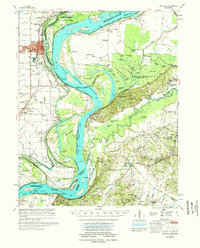
1977 Map of Osceola
USGS Topo · Published 1977About this map
The Mississippi River creates a dynamic border between Arkansas and Tennessee, defined here by shifting bars and towheads like Kate Aubrey Towhead and Sunrise Towhead. The Arkansas side is anchored by the river port of Osceola, where the St Louis San Francisco railroad services the agricultural flatlands. This 1970s landscape is deeply tied to the river's hydrology, featuring extensive flood control measures including the Driver Cut-Off and numerous revetments. On the Tennessee bank, the elevation rises sharply at Chickasaw Bluff No 1, overlooking the Anderson-Tully State Wildlife Management Area and Fort Pillow State Park. Inland, numerous small communities such as Nodena, Gilt Edge, and Luxora are connected by a network of drainage ditches and small churches, including Mt Herman Ch and Bright Hill Ch, reflecting the rural social fabric of the Mississippi Delta.
Find a feature on this map
117 named features on this map. Tap any name to fly to it.
Don’t see what you’re looking for? This feature index may not catch every label — zoom into the map to look around manually.
Map Details
Editions of this 1977 Osceola Map
This is the sole edition of this map. No revisions or reprints were ever made.
Other maps of this area

1931 · Jericho
USGS Topo · 1:62,500

1939 · Jericho
USGS Topo · 1:62,500

1939 · Hales Point
USGS Topo · 1:62,500

1939 · Blytheville
USGS Topo · 1:62,500

1939 · Evadale
USGS Topo · 1:62,500

1941 · Manila
USGS Topo · 1:62,500

1942 · Millington
USGS Topo · 1:62,500

1952 · Jericho
USGS Topo · 1:62,500

1952 · Hales Point
USGS Topo · 1:62,500

1953 · Memphis
USGS Topo · 1:250,000