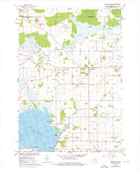
1961 Map of Oshkosh NW
USGS Topo · Published 1976About this map
Winchester and Larsen anchor the rural landscape of northern Winnebago County in this mid-century survey, updated to reflect the mid-1970s. The terrain is defined by the marshy reaches of the Rat River and Arrowhead River, which drain into the expansive Lake Winneconne at the map's southern edge. Settlement patterns are largely dictated by these waterways and the Soo Line railroad passing through the eastern corridor. Genealogists will find significant local records through the inclusion of family-centric landmarks and numerous burial sites, such as St Peters Cem, Royer Cem, and Winchester Cem. The map highlights the area's geological utility through numerous labeled Gravel Pits and Quarries that dot the townships of Winchester and Clayton, illustrating a landscape shaped by both small-scale industry and the natural shoreline features like Clarks Point and Harpers Point.
Find a feature on this map
30 named features on this map. Tap any name to fly to it.
Don’t see what you’re looking for? This feature index may not catch every label — zoom into the map to look around manually.
Map Details
Editions of this 1961 Oshkosh NW Map
2 editions found
Other maps of this area

1955 · Green Bay
USGS Topo · 1:250,000

1956 · New London
USGS Topo · 1:48,000

1956 · Weyauwega
USGS Topo · 1:48,000

1961 · Oshkosh
USGS Topo · 1:24,000

1961 · Poy Sippi
USGS Topo · 1:62,500

1961 · Oshkosh
USGS Topo · 1:62,500

1961 · Lake Poygan
USGS Topo · 1:24,000

1961 · Oshkosh NE
USGS Topo · 1:24,000

1961 · Oshkosh NW
USGS Topo · 1:24,000
1961 · Eureka
USGS Topo · 1:24,000