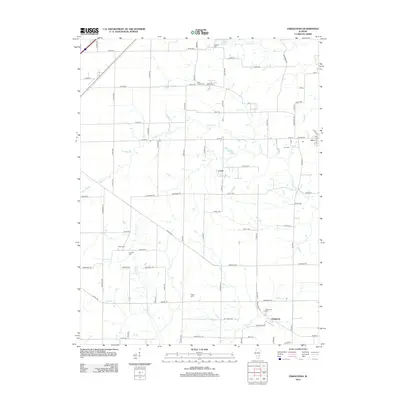
2012 Map of Oskaloosa
USGS Topo · Published 2012About this map
Oskaloosa and Iola serve as the primary anchors for this rural Clay County landscape, where the agricultural grid is intersected by a complex drainage network. The Skillet Fork and Crooked Creek carve through the terrain, accompanied by smaller waterways like Dismal Creek and Sutton Creek. This map is particularly notable for its density of burial sites, which offer significant value for genealogical research in the region. Beyond the central town cemeteries of Oskaloosa Cemetery and Iola Cemetery, the survey identifies several outlying locations including Negro Cemetery, Elder Cemetery, and Keen Chapel Cemetery. The small settlement of Cruse and the local Post Office in Iola further define the community structure during this period, while man-made features like Ging Lake and Patterson Lake dot the countryside.
Find a feature on this map
91 named features on this map. Tap any name to fly to it.
Don’t see what you’re looking for? This feature index may not catch every label — zoom into the map to look around manually.
Map Details
Editions of this 2012 Oskaloosa Map
This is the sole edition of this map. No revisions or reprints were ever made.
Other maps of this area

1934 · Salem
USGS Topo · 1:62,500

1938 · Salem
USGS Topo · 1:62,500

1945 · Kinmundy
USGS Topo · 1:62,500

1947 · Kinmundy
USGS Topo · 1:62,500

1952 · Xenia
USGS Topo · 1:62,500

1956 · Edgewood
USGS Topo · 1:62,500

1958 · Belleville
USGS Topo · 1:250,000

1962 · Belleville
USGS Topo · 1:250,000
1965 · Omega
USGS Topo · 1:24,000
1968 · Xenia
USGS Topo · 1:24,000