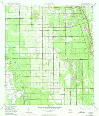
1949 Map of Oslo
USGS Topo · Published 1972About this map
Oslo and the southern reaches of Vero Beach anchor this coastal Florida landscape, where mid-century drainage projects and agricultural development meet the Atlantic shoreline. The Florida East Coast railway runs parallel to the coast, passing through Nevins and past the distinctive McKee Jungle Gardens. Inland, the terrain is defined by a rigid grid of canals and agricultural plots, punctuated by a Fish Hatchery and several planned residential developments like Royal Poinciana Park and Lakewood Park.
Find a feature on this map
21 named features on this map. Tap any name to fly to it.
Don’t see what you’re looking for? This feature index may not catch every label — zoom into the map to look around manually.
Map Details
Editions of this 1949 Oslo Map
3 editions found
Other maps of this area

1948 · Riomar
USGS Topo · 1:24,000

1948 · Indrio
USGS Topo · 1:24,000

1949 · Fort Pierce
USGS Topo · 1:24,000

1949 · Vero Beach
USGS Topo · 1:24,000

1949 · Oslo
USGS Topo · 1:24,000

1949 · Fort Pierce NW
USGS Topo · 1:24,000

1950 · Riomar
USGS Topo · 1:24,000

1950 · Fort Pierce
USGS Topo · 1:24,000

1950 · Fort Pierce NW
USGS Topo · 1:24,000

1950 · Oslo
USGS Topo · 1:24,000