
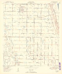
1950 Map of Oslo
USGS Topo · Published 1950About this map
Oslo and the southern outskirts of Vero Beach define the landscape of this coastal Florida corridor at the mid-century mark. The map traces a grid of agricultural and drainage infrastructure typical of the region's development, notably the South Canal and the Florida East Coast railway, which parallels the shoreline. A significant landmark of early Florida tourism, McKee Jungle Gardens, is situated just east of the rail line, representing the era's botanical and roadside attractions.
Find a feature on this map
15 named features on this map. Tap any name to fly to it.
Don’t see what you’re looking for? This feature index may not catch every label — zoom into the map to look around manually.
Map Details
Editions of this 1950 Oslo Map
2 editions found
Other maps of this area

1948 · Riomar
USGS Topo · 1:24,000

1948 · Indrio
USGS Topo · 1:24,000

1949 · Fort Pierce
USGS Topo · 1:24,000

1949 · Vero Beach
USGS Topo · 1:24,000

1949 · Oslo
USGS Topo · 1:24,000

1949 · Fort Pierce NW
USGS Topo · 1:24,000

1950 · Riomar
USGS Topo · 1:24,000

1950 · Fort Pierce
USGS Topo · 1:24,000

1950 · Fort Pierce NW
USGS Topo · 1:24,000

1950 · Indrio
USGS Topo · 1:24,000