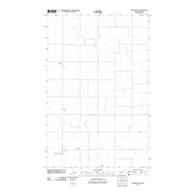
2011 Map of Osnabrock SW
USGS Topo · Published 2011About this map
Cavalier County farmland defines this landscape, where the township grid is punctuated by historic burial grounds and seasonal water bodies. The terrain is largely agricultural, marked by the winding path of the South Branch Park River in the northeast and the expansive Fairdale Slough to the southwest. Genealogists and local historians will find significant value in the distribution of family and community resting places, including Highland Cemetery, Soper Cemetery, and Silvesta Cemetery. In the southern portion of the quadrangle, Ohnstad Cemetery sits near the intersection of several section roads. The map illustrates a highly organized rural infrastructure, dominated by north-south corridors such as 114th Ave NE and County Rd 22, showing how the land has been partitioned for decades.
Find a feature on this map
19 named features on this map. Tap any name to fly to it.
Don’t see what you’re looking for? This feature index may not catch every label — zoom into the map to look around manually.
Map Details
Editions of this 2011 Osnabrock SW Map
This is the sole edition of this map. No revisions or reprints were ever made.
Other maps of this area

1953 · Devils Lake
USGS Topo · 1:250,000

1956 · Devils Lake
USGS Topo · 1:250,000

1972 · Osnabrock
USGS Topo · 1:24,000

1972 · Nekoma
USGS Topo · 1:24,000

1972 · Easby
USGS Topo · 1:24,000
1972 · Milton
USGS Topo · 1:24,000

1972 · Osnabrock SW
USGS Topo · 1:24,000

1972 · Adams
USGS Topo · 1:24,000

1972 · Fairdale
USGS Topo · 1:24,000

1972 · Edmore NE
USGS Topo · 1:24,000