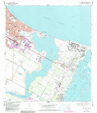
1968 Map of Oso Creek NE
USGS Topo · Published 1977About this map
Corpus Christi Naval Air Station and the surrounding residential growth of the late 1960s define this coastal landscape. The map captures a period of significant suburbanization along the shores of Corpus Christi Bay, with new developments like Lamar Park and Claremont Park replacing older coastal terrain. Educational and military infrastructure are prominent, from University of Corpus Christi on Ward Island to the expansive Waldron Field near Oso Creek.
Find a feature on this map
62 named features on this map. Tap any name to fly to it.
Don’t see what you’re looking for? This feature index may not catch every label — zoom into the map to look around manually.
Map Details
Editions of this 1968 Oso Creek NE Map
3 editions found
Other maps of this area

1925 · Aransas Pass
USGS Topo · 1:62,500

1925 · Oso Creek
USGS Topo · 1:62,500

1925 · Corpus Christi
USGS Topo · 1:62,500

1950 · Corpus Christi
USGS Topo · 1:250,000

1951 · Portland
USGS Topo · 1:24,000

1951 · Corpus Christi
USGS Topo · 1:24,000

1951 · Corpus Christi
USGS Topo · 1:62,500

1951 · Crane Islands NW
USGS Topo · 1:24,000

1951 · Oso Creek NW
USGS Topo · 1:24,000

1951 · Oso Creek NE
USGS Topo · 1:24,000