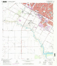
1968 Map of Oso Creek NW
USGS Topo · Published 1977About this map
Corpus Christi's southern expansion and military aviation footprint are captured here during a decade of rapid coastal growth. The airfield at Cabaniss Field dominates the central landscape, bordered by the Military Reservation Boundary and the U S Government Railroad. To the south, the winding course of Oso Creek cuts through a landscape increasingly marked by industrial utility, from numerous Gas Wells to the specialized NASA Tracking Station near the shoreline.
Find a feature on this map
63 named features on this map. Tap any name to fly to it.
Don’t see what you’re looking for? This feature index may not catch every label — zoom into the map to look around manually.
Map Details
Editions of this 1968 Oso Creek NW Map
Other maps of this area

1924 · Petronilla
USGS Topo · 1:62,500

1925 · Robstown
USGS Topo · 1:62,500

1925 · Oso Creek
USGS Topo · 1:62,500

1925 · Corpus Christi
USGS Topo · 1:62,500

1950 · Corpus Christi
USGS Topo · 1:250,000

1951 · Portland
USGS Topo · 1:24,000

1951 · Corpus Christi
USGS Topo · 1:24,000

1951 · Corpus Christi
USGS Topo · 1:62,500

1951 · Oso Creek NW
USGS Topo · 1:24,000

1951 · Oso Creek NE
USGS Topo · 1:24,000