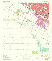
1968 Map of Oso Creek NW
USGS Topo · Published 1977About this map
Corpus Christi undergoes significant southward expansion in this mid-century survey, with residential growth pushing toward the meandering banks of Oso Creek. The landscape transition is evident where established city grids meet the larger tracts of the Military Reservation Boundary surrounding Cabaniss Field. Specialized infrastructure anchors the periphery, including the NASA Tracking Station to the southeast and the Corpus Christi Minor Seminary located near the urban edge. To the west, the terrain remains dominated by resource extraction and agriculture, marked by numerous Oil Wells, Gas Wells, and the Rancho Viejo Windmill. Notable community landmarks such as Driscoll Childrens Hospital and Wilson Hospital serve the growing population, while the U S Government Railroad provides a direct industrial link through the northern portion of the quadrangle.
Find a feature on this map
66 named features on this map. Tap any name to fly to it.
Don’t see what you’re looking for? This feature index may not catch every label — zoom into the map to look around manually.
Map Details
Editions of this 1968 Oso Creek NW Map
Other maps of this area

1924 · Petronilla
USGS Topo · 1:62,500

1925 · Robstown
USGS Topo · 1:62,500

1925 · Oso Creek
USGS Topo · 1:62,500

1925 · Corpus Christi
USGS Topo · 1:62,500

1950 · Corpus Christi
USGS Topo · 1:250,000

1951 · Portland
USGS Topo · 1:24,000

1951 · Corpus Christi
USGS Topo · 1:24,000

1951 · Corpus Christi
USGS Topo · 1:62,500

1951 · Oso Creek NW
USGS Topo · 1:24,000

1951 · Oso Creek NE
USGS Topo · 1:24,000