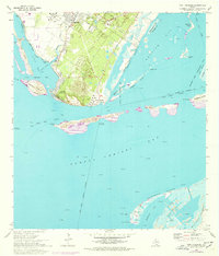
1968 Map of Port Ingleside
USGS Topo · Published 1977About this map
Ingleside and its coastal neighbors define the interface between industrial development and the barrier island ecology of the Texas Gulf Coast in the late 1960s. The landscape is heavily marked by the energy sector, featuring a large Refinery and Tank Farm connected by pipelines, alongside the Dagger Island Oil Field where offshore wells dot the shallow waters. Navigation and commerce are central to this area, shown through the engineered precision of the Intracoastal Waterway, La Quinta Channel, and the Corpus Christi Channel. The Southern Pacific railroad serves the mainland, while residential growth is concentrated at Ingleside-On-the-Bay. In contrast to the industrial zones, the map preserves the natural contours of the archipelago, including Mustang Island and Shamrock Island, which buffer the mainland from the open gulf.
Find a feature on this map
48 named features on this map. Tap any name to fly to it.
Don’t see what you’re looking for? This feature index may not catch every label — zoom into the map to look around manually.
Map Details
Editions of this 1968 Port Ingleside Map
2 editions found
Other maps of this area

1925 · Aransas Pass
USGS Topo · 1:62,500

1925 · Oso Creek
USGS Topo · 1:62,500

1925 · Corpus Christi
USGS Topo · 1:62,500

1950 · Corpus Christi
USGS Topo · 1:250,000

1951 · Portland
USGS Topo · 1:24,000

1951 · Corpus Christi
USGS Topo · 1:62,500

1951 · Crane Islands NW
USGS Topo · 1:24,000

1951 · Oso Creek NE
USGS Topo · 1:24,000

1951 · Oso Creek
USGS Topo · 1:62,500

1951 · Crane Islands
USGS Topo · 1:62,500