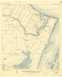
1925 Map of Oso Creek
USGS Topo · Published 1946About this map
The coastal plains of South Texas south of Corpus Christi are defined here by a network of ranching outposts and remote schoolhouses during the mid-1920s. Along the western banks of Oso Creek, agriculture and industry are represented by the Morgan Gin and various community nodes like the London School and Kostoryz School. The landscape is notably dotted with named windmills, such as the Guajolote Windmill and Los Sedros Windmill, which served as critical water sources for the cattle operations at El Camito Ranch and Portales Ranch.
Find a feature on this map
32 named features on this map. Tap any name to fly to it.
Don’t see what you’re looking for? This feature index may not catch every label — zoom into the map to look around manually.
Map Details
Editions of this 1925 Oso Creek Map
2 editions found
Other maps of this area

1924 · Petronilla
USGS Topo · 1:62,500

1925 · Robstown
USGS Topo · 1:62,500

1925 · Aransas Pass
USGS Topo · 1:62,500

1925 · Oso Creek
USGS Topo · 1:62,500

1925 · Corpus Christi
USGS Topo · 1:62,500

1928 · Sarita
USGS Topo · 1:125,000

1950 · Corpus Christi
USGS Topo · 1:250,000

1951 · Portland
USGS Topo · 1:24,000

1951 · Corpus Christi
USGS Topo · 1:24,000

1951 · Corpus Christi
USGS Topo · 1:62,500