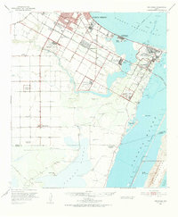
1951 Map of Oso Creek
USGS Topo · Published 1953About this map
Military aviation and coastal expansion dominate this early 1950s survey of the Encinal Peninsula and the surrounding bays. The landscape is heavily marked by the Corpus Christi Naval Air Station and its supporting airfields, including Rodd Field, Waldron Field, and Cabaniss Field. In the southern reaches, the transition from military infrastructure to agrarian life is evident near Chapman Ranch, where numerous named windmills like Coyote Windmill and Hacha Windmill dot the arid terrain leading toward the Laguna Madre.
Find a feature on this map
54 named features on this map. Tap any name to fly to it.
Don’t see what you’re looking for? This feature index may not catch every label — zoom into the map to look around manually.
Map Details
Editions of this 1951 Oso Creek Map
2 editions found

Other maps of this area

1924 · Petronilla
USGS Topo · 1:62,500

1925 · Robstown
USGS Topo · 1:62,500

1925 · Aransas Pass
USGS Topo · 1:62,500

1925 · Oso Creek
USGS Topo · 1:62,500

1925 · Corpus Christi
USGS Topo · 1:62,500

1928 · Sarita
USGS Topo · 1:125,000

1950 · Corpus Christi
USGS Topo · 1:250,000

1951 · Portland
USGS Topo · 1:24,000

1951 · Corpus Christi
USGS Topo · 1:24,000

1951 · Corpus Christi
USGS Topo · 1:62,500