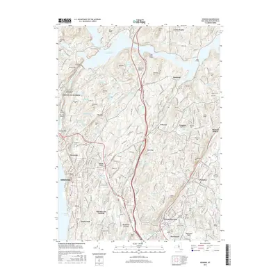
2016 Map of Ossining
USGS Topo · Published 2016About this map
Briarcliff Manor and the surrounding Westchester hills are defined by a complex network of reservoirs and suburban expansion in this modern survey. The massive New Croton Reservoir dominates the northern landscape, crossed by the New Croton Reservoir Bridge and Hunters Brook Bridge. This area serves as a critical watershed, where numerous smaller bodies of water like Teatown Lake and Indian Brook Reservoir are interspersed between growing residential pockets.
Find a feature on this map
112 named features on this map. Tap any name to fly to it.
Don’t see what you’re looking for? This feature index may not catch every label — zoom into the map to look around manually.
Map Details
Editions of this 2016 Ossining Map
This is the sole edition of this map. No revisions or reprints were ever made.
Other maps of this area

1892 · Stamford
USGS Topo · 1:62,500

1892 · West Point
USGS Topo · 1:62,500

1892 · Carmel
USGS Topo · 1:62,500

1892 · Tarrytown
USGS Topo · 1:62,500

1893 · Carmel
USGS Topo · 1:62,500

1893 · Stamford
USGS Topo · 1:62,500

1893 · Tarrytown
USGS Topo · 1:62,500

1894 · West Point
USGS Topo · 1:62,500
1894 · Carmel
USGS Topo · 1:62,500
1899 · Stamford
USGS Topo · 1:62,500