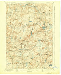
1918 Map of Oswegatchie
USGS Topo · Published 1926About this map
Benson Mines and the surrounding wilderness of the Adirondack foothills define this region during the height of its early 20th-century industrial activity. The New York Central railroad, specifically the Carthage and Adirondack Branch, provides the vital link for moving raw materials from the interior. Evidence of heavy utility and resource management is clear at the Browns Fall Power Plant and Maple Hill Dam, while remote settlements like Jayville and Aldrich anchor local life alongside numerous logging and sporting camps such as Streeter Camps and Humes Camp.
Find a feature on this map
135 named features on this map. Tap any name to fly to it.
Don’t see what you’re looking for? This feature index may not catch every label — zoom into the map to look around manually.
Map Details
Editions of this 1918 Oswegatchie Map
5 editions found

Other maps of this area

1903 · Big Moose
USGS Topo · 1:62,500

1911 · Lowville
USGS Topo · 1:62,500

1912 · Number Four
USGS Topo · 1:62,500

1913 · Lowville
USGS Topo · 1:62,500

1913 · Lake Bonaparte
USGS Topo · 1:62,500

1915 · Gouverneur
USGS Topo · 1:62,500

1915 · Number Four
USGS Topo · 1:62,500

1915 · Russell
USGS Topo · 1:62,500

1916 · Lake Bonaparte
USGS Topo · 1:62,500

1916 · Oswegatchie
USGS Topo · 1:62,500