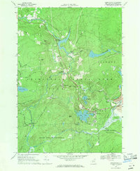
1966 Map of Oswegatchie
USGS Topo · Published 1971About this map
The Oswegatchie River dominates this portion of the Adirondack State Park, serving as the axis for both industrial development and early settlement. By the mid-1960s, the river’s power was harnessed at the Flat Rock Powerplant and Browns Fall Powerplant, while the Penn Central railroad tracks supported the heavy extraction operations at Benson Mines. This industrial infrastructure contrasts with the surrounding State Forest Preserve, where rugged terrain like Panther Mountain and Maple Mtn remained largely undeveloped.
Find a feature on this map
45 named features on this map. Tap any name to fly to it.
Don’t see what you’re looking for? This feature index may not catch every label — zoom into the map to look around manually.
Map Details
Editions of this 1966 Oswegatchie Map
3 editions found
Other maps of this area

1915 · Russell
USGS Topo · 1:62,500

1916 · Oswegatchie
USGS Topo · 1:62,500

1918 · Russell
USGS Topo · 1:62,500

1918 · Oswegatchie
USGS Topo · 1:62,500

1919 · Cranberry Lake
USGS Topo · 1:62,500

1921 · Cranberry Lake
USGS Topo · 1:62,500

1921 · Stark
USGS Topo · 1:62,500

1923 · Stark
USGS Topo · 1:62,500

1931 · Cranberry Lake
USGS Topo · 1:62,500

1940 · Stark
USGS Topo · 1:62,500