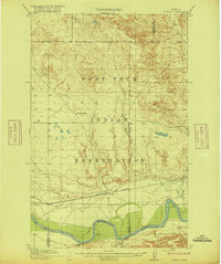
1915 Map of Oswego
USGS Topo · Published 1915About this map
Oswego serves as the primary railhead and settlement along the northern bank of the Missouri River in this 1915 survey. Located within the Fort Peck Indian Reservation, the landscape is defined by the east-west corridor of the Great Northern railroad, which provided vital transportation across the plains of Northeast Montana. The survey captures a moment before major irrigation or dam projects altered the Missouri's course, showing the natural meandering of the river and its southern tributaries like Elk Prairie Cr and Boxelder Cr. To the north, the terrain rises into the uplands, marked by landmarks such as Three Buttes and the drainage basins of Oswego Creek and Flynn Creek. The map also preserves the political geography of the era, illustrating the boundary line between Valley and Sheridan counties as it existed in the early twentieth century.
Find a feature on this map
17 named features on this map. Tap any name to fly to it.
Don’t see what you’re looking for? This feature index may not catch every label — zoom into the map to look around manually.
Map Details
Editions of this 1915 Oswego Map
2 editions found
Other maps of this area

1910 · Todd Lakes
USGS Topo · 1:62,500

1915 · Tule Valley
USGS Topo · 1:62,500

1915 · Frazer
USGS Topo · 1:62,500

1915 · Oswego
USGS Topo · 1:62,500

1915 · Todd Lakes
USGS Topo · 1:62,500

1915 · Spring Creek
USGS Topo · 1:62,500

1916 · Wolf Point
USGS Topo · 1:62,500

1954 · Jordan
USGS Topo · 1:250,000

1954 · Glendive
USGS Topo · 1:250,000

1954 · Wolf Point
USGS Topo · 1:250,000
Featured Places
- Wolf Point District, MT
- Prairie Elk Hutterite Colony, MT
- Frazer District, MT
- Oswego District, MT
- Oswego, Oswego District