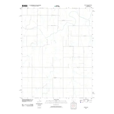
2009 Map of Otis NE
USGS Topo · Published 2009About this map
The Smoky Hill River meanders across this rural landscape in western Kansas, anchoring a drainage system that includes Duck Creek and the long, winding Eagle Creek. This 2009 survey reveals the highly structured agricultural grid that defines the region, where gravel and dirt routes such as Chetolah Gold Rd and Smoky Hill River Rd provide the primary access to sprawling farmsteads. For those interested in local genealogy or the history of the plains, the Pleasantdale Cemetery stands as a significant landmark in the southern half of the quadrangle. The map captures the quiet character of the Kansas countryside at the start of the 21st century, showing how the natural hydrology of the river basin interacts with the man-made section lines of the rural road network, including Stickney Rd and Michaelis Rd.
Find a feature on this map
16 named features on this map. Tap any name to fly to it.
Don’t see what you’re looking for? This feature index may not catch every label — zoom into the map to look around manually.
Map Details
Editions of this 2009 Otis NE Map
This is the sole edition of this map. No revisions or reprints were ever made.
Other maps of this area

1896 · Russell
USGS Topo · 1:125,000

1896 · Hays
USGS Topo · 1:125,000

1955 · Great Bend
USGS Topo · 1:250,000

1957 · Great Bend
USGS Topo · 1:250,000

1958 · Great Bend
USGS Topo · 1:250,000
1961 · Walker
USGS Topo · 1:24,000

1961 · Russell SW
USGS Topo · 1:24,000

1961 · Victoria
USGS Topo · 1:24,000
1965 · Otis
USGS Topo · 1:24,000
1966 · Bison
USGS Topo · 1:24,000