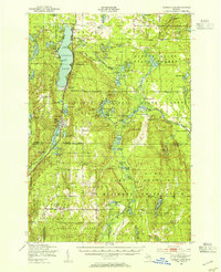
1949 Map of Otsego Lake
USGS Topo · Published 1954About this map
The northern Lower Peninsula landscape around Otsego Lake is captured here during the post-war era, showing a region defined by its vast conservation lands and glacial waters. The New York Central RR runs parallel to the western shore, serving the village of Waters and passing near local landmarks like the Otsego Lake Cem. Public lands dominate the topography, with the Pigeon River State Forest, Ausable State Forest, and Hartwick Pines State Park blanketing the terrain across the Otsego and Crawford county lines.
Find a feature on this map
87 named features on this map. Tap any name to fly to it.
Don’t see what you’re looking for? This feature index may not catch every label — zoom into the map to look around manually.
Map Details
Editions of this 1949 Otsego Lake Map
2 editions found
Other maps of this area

1949 · Lewiston
USGS Topo · 1:62,500

1949 · Otsego Lake
USGS Topo · 1:62,500

1949 · Fletcher
USGS Topo · 1:62,500

1949 · Grayling
USGS Topo · 1:62,500

1950 · Lake Margrethe
USGS Topo · 1:24,000

1950 · Grayling
USGS Topo · 1:24,000

1950 · Johannesburg
USGS Topo · 1:24,000

1950 · Lovells
USGS Topo · 1:24,000

1950 · Turtle Lake
USGS Topo · 1:24,000

1951 · K P Lake
USGS Topo · 1:24,000