
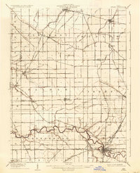
1908 Map of Ottawa
USGS Topo · Published 1936About this map
Ottawa serves as the focal point of this Northwest Ohio landscape, surveyed shortly after the turn of the century when steam and electric rail dominated local transport. The village is a dense hub of converging lines, including the Detroit Toledo and Ironton RR and the Lima and Defiance Electric RR. To the west, Glandorf remains centered around its grid, while the Blanchard River and Ottawa River meander through the southern townships, punctuated by smaller hamlets like Cuba and Kieferville.
Find a feature on this map
56 named features on this map. Tap any name to fly to it.
Don’t see what you’re looking for? This feature index may not catch every label — zoom into the map to look around manually.
Map Details
Editions of this 1908 Ottawa Map
2 editions found
Other maps of this area

1906 · Columbus Grove
USGS Topo · 1:62,500

1907 · Bluffton
USGS Topo · 1:62,500

1907 · Defiance
USGS Topo · 1:62,500

1908 · Columbus Grove
USGS Topo · 1:62,500

1908 · Napoleon
USGS Topo · 1:62,500

1909 · Mc Clure
USGS Topo · 1:62,500

1909 · Defiance
USGS Topo · 1:62,500

1909 · Continental
USGS Topo · 1:62,500

1911 · Delphos
USGS Topo · 1:62,500

1944 · Delphos
USGS Topo · 1:62,500