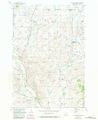
1954 Map of Otter Creek School
USGS Topo · Published 1982About this map
The high plains of Sweet Grass County are defined by a network of ranching homesteads and small country schools in this mid-century survey. Irrigation infrastructure, including the Timber Creek Canal and Rudd Ditch, reveals the intensive effort to water the landscape for livestock. Local social hubs are clearly marked, such as the Community Hall and multiple rural educational outposts like Otter Creek School and Wormser School.
Find a feature on this map
39 named features on this map. Tap any name to fly to it.
Don’t see what you’re looking for? This feature index may not catch every label — zoom into the map to look around manually.
Map Details
Editions of this 1954 Otter Creek School Map
Other maps of this area

1886 · Little Belt Mts.
USGS Topo · 1:250,000

1889 · Big Snowy Mountain
USGS Topo · 1:250,000

1891 · Livingston
USGS Topo · 1:250,000

1891 · Big Timber
USGS Topo · 1:125,000

1893 · Livingston
USGS Topo · 1:250,000

1893 · Big Snowy Mountain
USGS Topo · 1:250,000

1893 · Big Timber
USGS Topo · 1:125,000

1894 · Little Belt Mts.
USGS Topo · 1:250,000

1897 · Little Belt Mts.
USGS Topo · 1:250,000

1898 · Little Belt Mts.
USGS Topo · 1:250,000