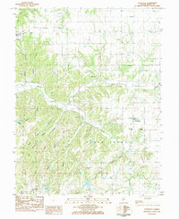
1983 Map of Otterville
USGS Topo · Published 1984About this map
Otterville and Fieldon anchor this early 1980s survey of western Illinois, where the landscape is defined by a complex network of ridges and hollows. The rugged drainage patterns of Otter Creek and its many tributaries, including Zahn Creek and Sandy Creek, create a deeply dissected terrain that influenced local settlement and burial sites. Genealogists will find an exceptional density of family and community burial grounds, from the St Marys Cem and Grimes Cem in the north to the Hamilton Cem and Dougherty Cem near Otterville.
Find a feature on this map
44 named features on this map. Tap any name to fly to it.
Don’t see what you’re looking for? This feature index may not catch every label — zoom into the map to look around manually.
Map Details
Editions of this 1983 Otterville Map
This is the sole edition of this map. No revisions or reprints were ever made.
Other maps of this area

1903 · O'Fallon
USGS Topo · 1:125,000

1927 · St. Charles
USGS Topo · 1:62,500

1930 · Hardin
USGS Topo · 1:62,500

1930 · Jerseyville
USGS Topo · 1:62,500

1931 · Brussels
USGS Topo · 1:62,500
1933 · Jerseyville
USGS Topo · 1:62,500

1933 · Saint Charles
USGS Topo · 1:62,500

1934 · Hardin
USGS Topo · 1:62,500

1938 · Hardin
USGS Topo · 1:62,500

1939 · Brussels
USGS Topo · 1:62,500