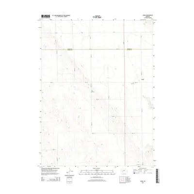
2014 Map of Ough
USGS Topo · Published 2014About this map
Ough sits at the eastern edge of this High Plains landscape, a small settlement defined by its position on the high tablelands above the drainage of Muddy Cr. The area is characterized by a precise grid of rural section roads, including Road 724 and 339 Ave, which facilitate the agriculture of the Nebraska panhandle. Genealogists and local historians will find value in the location of the Ough Cem near the town site, as well as the secluded Sleepy Hollow Cem situated further west along Avenue 336. The northern portion of the map is bisected by the Chase Co Dundy Co boundary line, marking the transition between these two Nebraska counties just south of the 727 Rd corridor.
Find a feature on this map
22 named features on this map. Tap any name to fly to it.
Don’t see what you’re looking for? This feature index may not catch every label — zoom into the map to look around manually.
Map Details
Editions of this 2014 Ough Map
This is the sole edition of this map. No revisions or reprints were ever made.
Other maps of this area
1954 · McCook
USGS Topo · 1:250,000
1957 · McCook
USGS Topo · 1:250,000
1958 · McCook
USGS Topo · 1:250,000
1973 · Champion
USGS Topo · 1:24,000
1973 · Enders
USGS Topo · 1:24,000
1973 · Champion SW
USGS Topo · 1:24,000
1973 · Ough
USGS Topo · 1:24,000
1973 · Wauneta SW
USGS Topo · 1:24,000
1973 · Benkelman NW
USGS Topo · 1:24,000
1973 · Rock Canyon
USGS Topo · 1:24,000