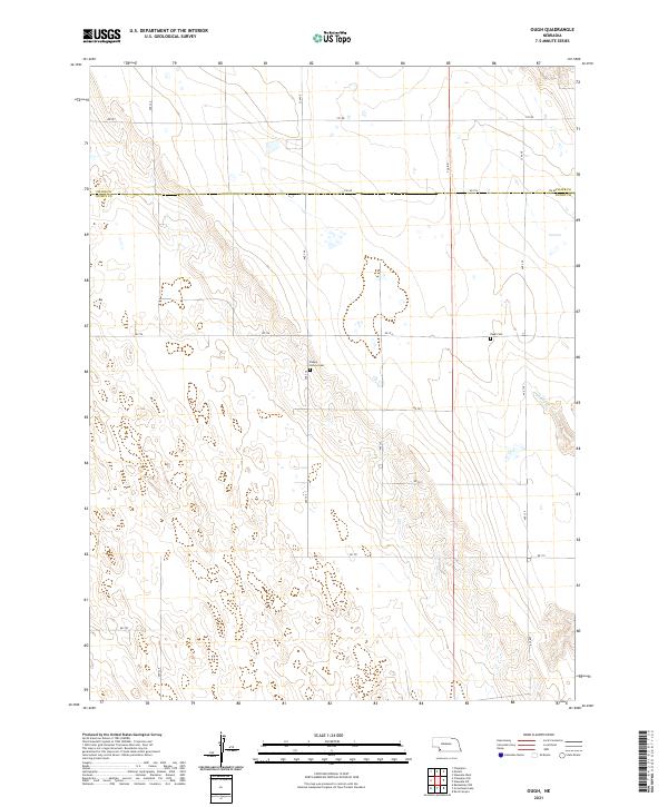
2021 Map of Ough
USGS Topo · Published 2021About this map
Ough Cem and Sleepy Hollow Cem are central landmarks in this rural landscape at the border of Chase and Dundy counties. The terrain is defined by the winding course of Muddy Creek and a network of section-line roads like Road 724 and Avenue 336. This modern survey reveals a highly structured agricultural grid, where the Public Land Survey System divisions—including townships t4n r37w and t4n r38w—remain the primary framework for land ownership and movement. The presence of two distinct cemeteries suggests a history of small, dispersed prairie communities that relied on these roads to connect isolated farmsteads.
Find a feature on this map
26 named features on this map. Tap any name to fly to it.
Don’t see what you’re looking for? This feature index may not catch every label — zoom into the map to look around manually.
Map Details
Editions of this 2021 Ough Map
This is the sole edition of this map. No revisions or reprints were ever made.
Other maps of this area

1954 · McCook
USGS Topo · 1:250,000

1957 · McCook
USGS Topo · 1:250,000

1958 · McCook
USGS Topo · 1:250,000

1973 · Champion
USGS Topo · 1:24,000

1973 · Enders
USGS Topo · 1:24,000

1973 · Champion SW
USGS Topo · 1:24,000

1973 · Ough
USGS Topo · 1:24,000

1973 · Wauneta SW
USGS Topo · 1:24,000
1973 · Benkelman NW
USGS Topo · 1:24,000
1973 · Rock Canyon
USGS Topo · 1:24,000