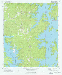
1971 Map of Our Town
USGS Topo · Published 1977About this map
The intricate shoreline of Martin Lake dominates this 1971 survey of the Tallapoosa River valley, where the rising waters of the reservoir created a complex network of peninsulas and islands. Wind Creek State Park occupies a significant portion of the northern waterfront, featuring a dedicated Picnic Area and Campground that highlight the area's mid-century development into a recreational hub.
Find a feature on this map
25 named features on this map. Tap any name to fly to it.
Don’t see what you’re looking for? This feature index may not catch every label — zoom into the map to look around manually.
Map Details
Editions of this 1971 Our Town Map
2 editions found
Other maps of this area

1901 · Wetumpka
USGS Topo · 1:125,000

1901 · Wetumpka
USGS Topo · 1:62,500

1903 · Wetumpka
USGS Topo · 1:125,000

1906 · Dadeville
USGS Topo · 1:125,000

1953 · Montgomery
USGS Topo · 1:250,000

1955 · Phenix City
USGS Topo · 1:250,000

1956 · Montgomery
USGS Topo · 1:250,000

1957 · Phenix City
USGS Topo · 1:250,000

1957 · Montgomery
USGS Topo · 1:250,000

1958 · Phenix City
USGS Topo · 1:250,000