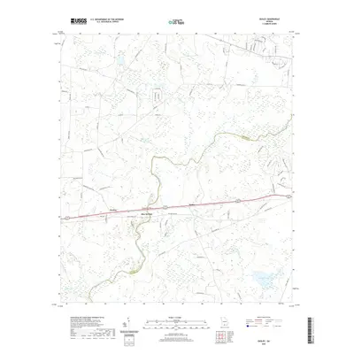
2020 Map of Ousley
USGS Topo · Published 2020About this map
The Withlacoochee River carves a serpentine path through the borderlands of Brooks and Lowndes Counties, defining the drainage patterns of this South Georgia landscape. In this 2020 survey, the small community of Ousley sits along the primary east-west highway corridor, flanked by the settlements of Durden and Blue Springs. The map reveals a transition from the dense swampy bottomlands near the river and its tributaries, such as Tiger Cr and Okapilco Cr, to the upland residential developments appearing in the northeast corner near Troupeville Hwy. Genealogists may find interest in the location of Lebanon Cem near the western edge. Notable water features like Langdale Lake and the aptly named Millrace Cr provide insight into the historical and modern water management of the region, while a network of rural roads like Crosbytown Rd connects the scattered homesteads and agricultural tracts.
Find a feature on this map
75 named features on this map. Tap any name to fly to it.
Don’t see what you’re looking for? This feature index may not catch every label — zoom into the map to look around manually.
Map Details
Editions of this 2020 Ousley Map
This is the sole edition of this map. No revisions or reprints were ever made.
Other maps of this area

1954 · Valdosta
USGS Topo · 1:250,000

1956 · Clyattville
USGS Topo · 1:24,000

1956 · Nankin
USGS Topo · 1:24,000

1956 · Baden
USGS Topo · 1:24,000

1958 · Valdosta
USGS Topo · 1:250,000

1959 · Valdosta
USGS Topo · 1:250,000

1961 · Hahira East
USGS Topo · 1:24,000

1961 · Quitman
USGS Topo · 1:62,500

1961 · Valdosta
USGS Topo · 1:24,000

1961 · Hahira West
USGS Topo · 1:24,000