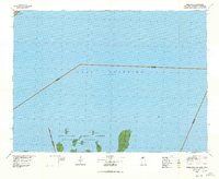
1978 Map of Outer Island
USGS Topo · Published 1978About this map
Lake Superior dominates this late-1970s nautical and topographic landscape, marking the convergence of Wisconsin, Minnesota, and Michigan borders. The southern portion of the map is defined by the Apostle Islands, many of which are protected within the Apostle Islands National Lakeshore. These islands vary from the isolated Devils Island in the west to the elongated Outer Island in the east, which features the Outer Island Light at its northern tip and a Landing Strip further south.
Find a feature on this map
24 named features on this map. Tap any name to fly to it.
Don’t see what you’re looking for? This feature index may not catch every label — zoom into the map to look around manually.
Map Details
Editions of this 1978 Outer Island Map
This is the sole edition of this map. No revisions or reprints were ever made.
Other maps of this area

1919 · Grand Marais
USGS Topo · 1:62,500

1919 · Lutsen
USGS Topo · 1:62,500

1941 · Bayfield
USGS Topo · 1:48,000

1944 · Cornucopia
USGS Topo · 1:48,000

1946 · Cornucopia
USGS Topo · 1:48,000

1946 · Bayfield
USGS Topo · 1:48,000

1953 · Ashland
USGS Topo · 1:250,000

1954 · Two Harbors
USGS Topo · 1:250,000

1955 · Tofte
USGS Topo · 1:24,000

1955 · Schroeder
USGS Topo · 1:24,000