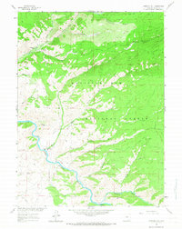
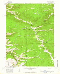
1961 Map of Overlook Hill
USGS Topo · Published 1967About this map
The North Platte River winds through this mountain landscape within the Medicine Bow National Forest, illustrating a mid-century period of land management and ranching. The map details a complex irrigation network including the Hubbell Ditch, Finfrock Ditch, and Anderson Ditch, which redirect water from alpine tributaries to support lower valley operations. Established ranching properties like the A Bar A Ranch and French Creek Ranch appear alongside recreational sites such as the French Creek Picnic Ground and Douglas Creek Picnic Ground. This 1961 survey, mapped as part of the Missouri River Basin development program, shows a rugged terrain defined by significant elevations like Overlook Hill and Stovepipe Hill. The density of named water features, from South French Creek to Savage Run Creek, underscores the critical role of mountain snowmelt in the local hydrological system.
Find a feature on this map
30 named features on this map. Tap any name to fly to it.
Don’t see what you’re looking for? This feature index may not catch every label — zoom into the map to look around manually.
Map Details
Editions of this 1961 Overlook Hill Map
3 editions found
Other maps of this area

1906 · Medicine Bow
USGS Topo · 1:125,000

1908 · Medicine Bow
USGS Topo · 1:125,000

1939 · Saratoga
USGS Topo · 1:125,000

1954 · Rawlins
USGS Topo · 1:250,000

1958 · Rawlins
USGS Topo · 1:250,000
1961 · Elkhorn Point
USGS Topo · 1:24,000

1961 · Overlook Hill
USGS Topo · 1:24,000

1961 · Ryan Park
USGS Topo · 1:24,000
1961 · Trent Creek
USGS Topo · 1:24,000
1961 · Horatio Rock
USGS Topo · 1:24,000