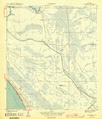
1943 Map of Overstreet
USGS Topo · Published 1943About this map
St Joseph Bay and the Gulf Coast's intricate hydrological network define this wartime survey of Gulf County. The Intracoastal Waterway cuts a straight path through a landscape dominated by swamp and sloughs, connecting the Wetappo region to the interior. Small settlements and specialized locations, such as Overstreet and the isolated Ringjaw Camp, punctuate the wetlands, while a Fire Tower stands as a sentinel over the low-lying terrain. The coastal margin is marked by prominent Sand Dunes along the bay, transitioning into a labyrinth of named water features like Harrison Lake and Whitfield Slough. One notable genealogical landmark is the Sharp Hardy Homestead, positioned near the headwaters of Long Branch, providing a rare specific reference to local residency and land use during this era.
Find a feature on this map
22 named features on this map. Tap any name to fly to it.
Don’t see what you’re looking for? This feature index may not catch every label — zoom into the map to look around manually.
Map Details
Editions of this 1943 Overstreet Map
5 editions found
Other maps of this area

1943 · Port St. Joe
USGS Topo · 1:31,680

1943 · Overstreet
USGS Topo · 1:31,680

1944 · Beacon Hill
USGS Topo · 1:31,680

1944 · White City
USGS Topo · 1:24,000

1945 · Lake Wimico
USGS Topo · 1:31,680

1945 · White City
USGS Topo · 1:31,680

1945 · Allanton
USGS Topo · 1:31,680

1945 · Wewahitchka
USGS Topo · 1:31,680

1945 · Wetappo Creek
USGS Topo · 1:31,680

1945 · St Joseph Point
USGS Topo · 1:31,680